Ross-on-Wye
Mile Markers
Originally these started out as milestones (from the Latin milliarium) which were, as the name suggests, made of stone but more recently have been made of metal or concrete. Thus the signs are more generally now known as mile markers, although milestone is still often used, as a general term to cover the various types.
Mile markers were constructed to indicate distance to the destination and from the place of origin. They also served to reassure the traveller that the proper route was being followed (like a forerunner to SatNav).
A Brief History1
Milestones were originally made of stone, such as granite, marble or a suitable local stone, in the form of a standing stone or obelisk. They date back to when people first started making more regular journeys between towns and cities and they are a series of numbered markers placed along a road at regular intervals normally at at the side of the road. Milestones were widely used by road builders during the Roman Empire and were an important part of the Roman road network because the distance travelled per day may only have been a few miles.
The first Roman milestones are thought to have appeared on the Appian way and at the centre of Rome was the Golden Milestone, which is now lost, which was made of bronze and marked the symbolic centre of the Roman Empire.
Locations
The locations of the markers can be found from OS maps (most easily seen on the 1" maps).
Around Ross
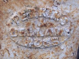
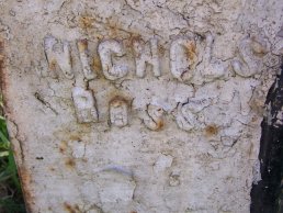
There are a number of Mile Markers around Ross. Many of them were made by Perkins and Bellamy or by by Nichols Ross.
 Perkins and Bellamy makers mark Perkins and Bellamy makers mark |  Nichols makers mark Nichols makers mark |
A49 Mile Markers
The A49 runs north-west from Ross (more precisely from Wilton) to Hereford and along the way there are several mile markers remaining.
Ross Turnpike Trust
The Ross Turnpike Trust controlled the road from Ross to Harewood End. The trust was responsible for the upkeep of the road and was responsible for the mile markers along that stretch of the road and so the markers are all of a similar design and are nearly always on the right hand side of the road
when coming from Ross.
Bridstow Parish no. 1
| | This marker on the side of the A49 at Bridstow, which has unfortunately been defaced. It shows that it is in the Parish of Bridstow and 13 miles to Hereford and 1 mile to Ross. |
Peterstow Parish no. 1
| | This marker on the side of the A49 at the Red Lion, Winters Cross, is unfortunately buried in the verge. It shows that it is in the Parish of Peterstow and 11 miles to Hereford and 3 miles to Ross.
The other Peterstow mile marker which showed 2 miles to Ross, just on the Ross side of Peterstow, has so far not been found but it was there within living memory. |
Hentland Parish no. 1
| This marker on the side of the A49 at Pengethley shows that it is in the Parish of Hentland and 10 miles to Hereford and 4 miles to Ross. | |
Hentland Parish no. 2
| | This marker on the side of the A49 at Harewood End shows that it is in the Parish of Hentland and 9 miles to Hereford and 5 miles to Ross. |
Hereford Turnpike Trust
The Hereford Trust was responsible for the road from Hereford to Harewood End at which point the Ross Trust took over responsibility for the road.
| This marker on the side of the A49 at Potway would have shown that it is 6 Miles to Hereford. This is the bottom of a stone pillar and would have had a plate
attached showing the distance but it is broken off where the plate would have been (possibly when the plate was removed). | |
| | This marker on the side of the A49 at Potway would have shown that it is 3 Miles to Hereford. This is the bottom of a stone pillar and would have had a plate
attached showing the distance but it is broken off close to the ground. |
| This marker on the side of the A49 at Bullinghope shows that it is 2 Miles to Hereford. This is a stone pillar with a plate attached showing the distance. This is possibly a replacement plate. | |
| | This marker on the side of the A49 at Hereford shows that it is 1 Mile to Hereford. This is a stone pillar with a plate attached showing the distance. This is believed to be the original plate. |
Missing Mile markers
These mile markers are noted as being missing and have been seen within living memory or are marked on maps.
- Peterstow - 2 miles to Ross 12 miles to Hereford
- Windmill Hill - 6 miles to Ross 8 miles to Hereford
- These markers are shown as being present on 1" OS-maps but now seems to have vanished.
B4234 Mile Markers
The B4234 runs south out of Ross down the Wye Valley through Walford, Kerne Bridge and onwards to Lydbrook. Several markers are remaining along this route, some are easier to find than others.
Ross Parish
| | This marker on the side of the Walford Road at Tudorville and shows that it is in the Parish of Ross and 5 miles to Lydbrook and 1 mile to Ross. |
Walford Parish No. 1
| | This marker is the first Walford Parish one out from Ross. It show that it is 4 miles to Lydbrook and 2 miles to Ross. It is hidden in the hedge and difficult to find. |
Walford Parish No. 2
| This marker, that has unfortunately been knocked over, is on the side of the Ross Road at Kerne Bridge and shows that it is in the Parish of Walford. The markings show that it is 2 miles to Lydbrook and 4 miles to Ross. | |
Missing mile markers
These mile markers are noted as being missing and have been seen within living memory.
- Old Post Office at Bishopswood
- There was one just past the old Post Office at Bishopswood near to the telephone box. Does anyone know where it is now?
- Near The Smithy, Walford
- This one has apparently been removed and is now in a garden. Does anyone know which garden or where it is?
A40 Mile Markers
The A40 runs to Monmouth, on through Pencraig and enters Ross from the south-west. It then exits south-east and goes through Weston-under-Penyard, Lea, Huntley
and on past Gloucester.
Wilton - Bridstow Parish
| This is the 2nd mile marker at Bridstow. This one is on the side of the A40 towards Monmouth and shows that it is in the Parish of Bridstow and
9 miles to Monmouth and 1 mile to Ross. Interestingly, this is the only cast iron mile marker (examined so far) with the makers mark on the left side rather than the right. | |
Weston Parish
| | This marker on the side of the Gloucester Road, the A40, at Weston-under-Penyard. It shows that it is in the Parish of Weston and is 14 miles to Gloucester and 2 miles to Ross. It was manufactured by Perkins and Bellamy, Ross. |
| This marker on the side of the Gloucester Road, the A40, at Ryeford and has been badly damaged. It showed that it is in the Parish of Weston and showed that it was 13 miles to Gloucester and shows that it is 3 miles to Ross. It was manufactured by Perkins and Bellamy, Ross. | |
Lea Parish
| | This marker on the side of the A40, at Lea. It shows that it is in the Parish of Lea and is 12 miles to Gloucester and 4 miles to Ross.
It was manufactured by Perkins and Bellamy, Ross. |
| | This marker on the side of the A40, at Lea Line. It shows that it is in the Parish of Lea and is 11 miles to Gloucester and 5 miles to Ross.
It was manufactured by Nichols Ross.  |
Box Bush
This stone mile marker is at Box Bush and shows that it is 10 miles to Gloster [Gloucester] and 6 miles to Ross.
A stud, which forms part of the datum mark on the top, has been driven into the marker and this has caused it to crack. Someone has done a repair on it which has stopped pieces from being lost but
it looks like some more work is needed to reduce the likelihood of it breaking up further.
Huntley
This stone mile marker is at Huntley on the side of the A40. It states that it is 7 miles to Gloster [Gloucester] and 9 miles to Ross.
Birdwood
This stone mile marker is between Birdwood and Churcham on the side of the A40. It states that it is 5 miles to Gloster [Gloucester] and 11 miles to Ross.
| | On the right hand side of the mile marker is what looks like a datum line. There is a line with an arrow point up to it from below (see photo below). |
Churcham
This stone mile marker is at Churcham on the side of the A40. It states that it is 4 miles to Gloster [Gloucester] and 12 miles to Ross.
Beauchamp
This stone mile marker is near to Beauchamp House on the side of the A40. It states that it is 3 miles to Gloster [Gloucester] and 13 miles to Ross.
Missing Mile markers
These mile markers are noted as being missing and have been seen within living memory or are marked on maps.
- Hildersley
- The marker at Hildersley (probably a Perkins and Bellamy) is marked on the 1" maps but now seems to have vanished.
A449 Mile Markers
These mile markers are on the A449 which runs between Ross and Ledbury.
| | This mile marker is on the A449 between Ross-on-Wye and Ledbury and states that it is 4 miles to Ross and 8 miles to Ledbury and in the parish of Upton Bishop. |
| The marker is in a poor condition but the makers mark can be made out as Perkins and Bellamy Ross. | |
In the Area
Crow Hill
| This is a mile marker just south of Crow Hill which has had its face removed. It would have originally had a metal face bolted onto it denoting the distances. It has a distinctive mark on it of a line with a V shape above it which is a datum mark which was used when surveying as it was a reference point at a known height.
| |
Eastbach Mile Marker
| | This mile marker is at Eastbach (on the edge of the Forest of Dean) and it states that it is 17 miles to Gloster [Gloucester] and 122 miles to London. Below that is a datum line/marker. |
Redmarley Parish
| | This mile marker is near to Redmarley and it states that it is 9 miles to Gloucester and 7 miles to Ledbury.
On it is stated that it is in the County of Worcester and it is dated 1898. It was manufactured by M & W Grazebrook who were Iron Founders in Dudley. |
Missing markers
After some searching, the following is a list of misc. markers that seem to have gone missing relatively recently.
- Marker north of Fidlers Cross
1 Milestone -
http://en.wikipedia.org/wiki/Milestone - 29th March 2008
[Page updated: Feb 15 2011 13:31:59]